Screenshots


iPad screenshots


Icon palette
About this app
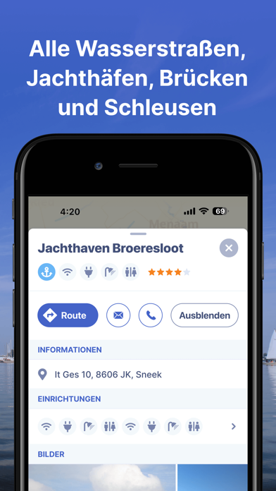
Die Navi- und Routenplaner-App für eine stressfreie Zeit auf dem Wasser. Mit Routenplaner, Gewässerkarten, AIS-Kopplung, Marinas, Brücken und Schleusen, Offline-Nutzung und mehr. Testen Sie jetzt kostenlos und planen Sie Ihre nächste Reise! Mit der Waterkaarten-App (ehemals ANWB Waterkaarten) haben Sie alles, was Sie für eine stressfreie Zeit auf dem Wasser brauchen: • 12 Länder, 1 Preis: Vollständige Gewässerkarten für Deutschland, Niederlande, Belgien, Frankreich, Österreich, Tschechien, Großbritannien, Irland, Dänemark, der Schweiz und Skandinavien. • Almanach-Infos: Alle Infos die Sie auf dem Wasser brauchen, in einer App abrufbar • Aktuelle Infos zu Brücken, Schleusen, Liegeplätzen inklusive Öffnungszeiten • Planen Sie optimale Routen zwischen Ihrem Liegeplatz und dem Zielort — inklusive den Brücken und Schleusen, die Ihnen auf dem Weg begegnen • AIS+: Sehen Sie auf einen Blick a…
App details
What you can learn from Waterkaarten: Boot Navigation
Every shipping app on the App Store has gone through the same decisions you're working through right now: which screenshot goes first, what caption sits over it, which device frame to show, what color the background should be. The 18 screenshots above are Waterkaarten: Boot Navigation's answers to those questions — they're public, they're real, and they made it through Apple's review.
Notice the first screenshot in particular. It's the one users see in search results and on the product page, and it's where most apps spend their best caption and tightest design. Look at the proportion of background to phone, where the text sits, what one thing the image is trying to communicate.
Want to see how other Navigation apps approach the same problem? Browse more Navigation apps in the showcase.
Take what works into your own screenshots
Open LaunchShots and design your App Store & Google Play screenshots — pick a device frame, drop captions, ship in minutes. Free, in your browser.
Open the screenshot editor →