Screenshots


Icon palette
About this app
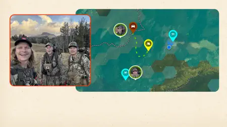
Navigate your next hunt and view species distribution, lidar topo maps, and hunting units. Know where you stand with private and public land boundaries. Maximize your hunting experience with onX Hunt and explore features cultivated specifically for the Canadian hunter. View public land maps, Crown Lands, Outfitting Areas, Special Draw Zones, Furblock Units, and more, where available. Save Offline Maps, view terrain in 3D, and mark crucial locations with Waypoints. Research property lines and find new hunting opportunities across Canada or the United States. Find new areas to hunt by targeting nutrient-rich soil with our Historic Wildfire Layer. Monitor optimal weather conditions and access custom Map Layers, including data on wildlife distribution, trees, crops, or soil. View Trail Cameras for recent activity and Wind Calendars for stand locations. While hunting, access a GPS navigat…
App details
What you can learn from onX Hunt: GPS and 3D Topo Maps
Every shipping app on the App Store has gone through the same decisions you're working through right now: which screenshot goes first, what caption sits over it, which device frame to show, what color the background should be. The 6 screenshots above are onX Hunt: GPS and 3D Topo Maps's answers to those questions — they're public, they're real, and they made it through Apple's review.
Notice the first screenshot in particular. It's the one users see in search results and on the product page, and it's where most apps spend their best caption and tightest design. Look at the proportion of background to phone, where the text sits, what one thing the image is trying to communicate.
Want to see how other Navigation apps approach the same problem? Browse more Navigation apps in the showcase.
Take what works into your own screenshots
Open LaunchShots and design your App Store & Google Play screenshots — pick a device frame, drop captions, ship in minutes. Free, in your browser.
Open the screenshot editor →